Villages and parishes in the family history of William Ramsay (b 1810)
Baldridge Burn, Dalgety, Dunfermline, Fordel, Crossgates, Townhill, Gardener's Land, Coal Hill Kircaldy, Auchterderran, Little Dean,
Baldridge and Baldridge Burn
The Old "Fitpaths" and Streets of Dunfermline has a few entries on Baldridge and Baldridge Burn
18). Cholera Morbus. This terrible scourge reached Dunfermline on Sunday 2nd September 1832; “it made its first appearance in the suburb of Baldridge Burn, and caused great excitement and terror. A man named Mercer, a weaver, near Balridge Burn Toll, was the first who died in the district of cholera.” (M.S.) [Annals of D‟Line P.633]
19). The Baldridge Works, a comparatively small weaving factory was being built in 1839. [The Weavers‟ Craft by D. Thomson P.337]
20). Collier Row is shown on 1856 Map Dunfermline. On the west of this Row is shown and Old Coal Pit. Baldridge Row is shown as the same Row in 1896 Map. On the North side of Baldridgeburn is shown the Slaughter house, west side of the street and north of this is shown what was Baldridge Row. By 1915 the Row was shown as empty and by 1926 it had disappeared from the map. [D‟Line Public Library]
22). Baldridge Row, is connected with Wellwood Colliery, but I rather think that it enjoys no other local patronage or alliance. It is within 20 minutes walk of Dunfermline Cross, but nobody cares to confess it belongs to Dunfermline. It is indeed a most unsavoury place and is only saved from discreditable rivalry with some other Rows I have seen by the proprietor bestowing a little more care upon the houses, which must be somewhere about a hundred years old. A trench has been formed behind the Rows, which keep the interior a trifle drier than it would otherwise be, and ashes laid in the front, terminating in a tile drain, sere to make the doors tidier than one might expect to find them. The interior of some of the houses, however, is enough to make the boldest hold his breath for a time, the people themselves being more to blame for this than the Landlord, although he is not altogether guiltless. Baldridge Row, to state the case frankly, is one of many similar places, which should be improved off the face of the earth. In the first house we are introduced to an old woman of fourscore, living in a single apartment, which is low in the damp-stained ceiling, badly lighted, and altogether miserable. In her young days she worked in the pits, and is now permitted to sit rent free. Similar places further along the Row bring a rent, of 8d a week, and two apartments 4s 6d a month. In the second house, the rain finds its way through the roof above one of the beds, and on a recent wet Saturday the tenant removed her bedding, the “Tick” and the sheets being both wet. Outside the houses there are no conveniences of any kind. The Dunfermline water supply is available at Baldridge Row. [D‟Line Journal 27 .2.1875]
William Chambers' Gazetteer says
Baldridge colliery is also very extensive. It is situated within half a mile of Dunfermline, where the produce is much used. A new pit was lately sunk here, and a powerful steam-engine erected, to arrive at the splint seam, which is of great value and in much esteem. About a mile distant from the town is situated the Townhill colliery, which is wrought only on a small scale, and where the burgesses are entitled to be supplied at a cheaper rate than others.
The Ordnance Survey of 1853-55 lists places associated with Baldridgeburn. It has and entry for Baldridgeburn Street which says
"A tolerably long street extending from Rutherford's Mill to Rumblingwell Toll Bar, all along the south side of the street are houses and a few at the end on the North side varying from one to two stories in height and are occupied by Damask weavers. This place was formerly known as {..} district, but since it assumed the form of a street, Mr Kilgour and the Provost would recommend street to be added to distinguish it from an adjacent stream of the same name"
The next page adds more about Baldridge Factory:
Baldridge Factory (Disused) [Situation] About 2 chains E [East] of Coal Road. New and extensive buildings used until lately for the purpose of manufacturing Damask and Diaper cloths. The machinery in the building was worked by steam.
[Fife and Kinross-shire OS Name Books 1853-55 Volume 118 page 4]
Baldridgeburn can be seen in the following map about two miles north west of Dunfermline and from Townhill which is north east of Dunfermline town.
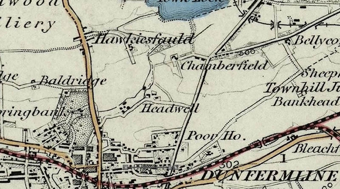
[source]
The family of Peter Burt and Euphans Penman are found at the 1841 census as living at Appin Crescent, Baldridgeburn, Dunfermline. The census eumerators book describes the area he was supposed to cover and this indicated the immediate surroundings of Appin Crescent
Description of Enumeration District 12 from the Enumerator’s Book 1841 Census ”District 12th Includes the east side of S & N Inglis Street the Baptist Chapel & twp adjoining houses in James Street, the Whole of the houses in Hollyblood Acres, the South Division of Downie Vale Crescent & Appin Terrace.” ALSO ”That part of the ancient royalty bounded by and included within a line commencing at the top of Shaddows Wynd and proceeding northwards along South and north Inglis Street to the boundary water run thence eastward along that boundary by the (run) to the Townhill road thence (???) eastward between the two divisions of Donibrisle Crescent to the Crossgates Road at the east end of Appin Terrace thence westward by Appin Terrace Martyr's Place and James Street to the top of Shaddows Wynd but excluding the ground and houses within the aforesaid (line ?) belonging to or holding of the proprietor of Pittencrieff” I found a reference to Appin Crescent in “The Old “Fitpaths” and Streets of Dunfermline”
APPIN CRESCENT 1). Situated at the top of the Public Park, east at the Sinclair Round-about. 2). The Loch (Townhill) and the surrounding lands had belonged to the burgh of Dunfermline until 6th December 1828, when the ground from just beyond Muir Street, Townhill to Appin Crescent, Dunfermline, was sold for £14,105 to Mr. Downie of Appin. Mr. Downie represented the Burgh in Parliament, and as payment of a debt to him the Burgh sold him that portion of land. [Townhill by W.D. Henderson P. 30] 3). About a mile and a quarter from the town, are the Townhill and Appin Collieries, the former belonging to the burgh of Dunfermline, and the latter to Mr Downie of Appin. [Chalmers Vol. 1. P.42] 4). This crescent of one story houses faces the south and stands on part of the south western boundary of the old Towngreen upon the line of road leading from Dunfermline to Crossgates, Kirkcaldy. The houses are about 10 feet from the side of the road. The space is generally laid out in flowerpots which display a taste and order highly creditable to the occupants of the houses and is a decided ornament to the city. The ground belonged to the Heirs of the late Robert Downie Esq. of Appin. [Viagraphy Dunfermlynensis Dunf Pub Library]
At the 1851 Census, the enumerator refines this description and adds the new railway that has been constructed:
Description of Enumeration District 12 from the Enumerator’s Book 1851 Census "That part of the ancient royalty bounded by and included within a line commencing at the top of Shaddows Wynd and proceeding northwards along South and North Inglis Street to the Boundary of the Ancient Royalty at the Water Run thence Eastward along that boundary by the (run) to the Townhill road thence still eastward through Downieville Crescent where it is intersected by the Edinburgh Perth & Dundee Railway keeping the south side of said Railway to the Crossgates Road at the east end of Appin Terrace thence westward by Appin Terrace Martyr’s Place and James Street to the top of Shaddows Wynd but excluding the ground and houses within the aforesaid (line ?) belonged to or are held of the Proprietor of Pittencrieff” now the property of the Edinburgh Perth & Dundee Railway Company. Thus including the East side of South and North Inglis Streets, South Division of Downieville Crescent, Appin Terrace, Martyr’s Place, and the Baptist Chapel and the two houses to the east thereof on the North side of James Street"
To summarise, then, Baldridge Burn was a weaving centre (the two-page spread of the baptismal register that Euphan Burt was recorded in in 1815 contained 12 entries. The occupations of the fathers were 12 weavers, 1 coal hewer, 1 labourer) but also a major coal mining area which grew with the expansion fo the railways.

Dunfermline Overview
The following description of Dunfermline from William Chambers' Gazetteer of Scotland 1800-1833 includes references to a number of the towns and villages that our Ramsay ancestors lived in
DUNFERMLINE, a parish in the western district of Fife, of about eight miles in length by five in breadth, bounded by Cleish on the north, Carnock and Torryburn on the west, and Beath and Inverkeithing on the east. The parish of Inverkeithing also separates it in a great measure from the Firth of Forth on the south, and in this quarter it presents only a small corner to the shore, on which the seaport villages of Charlestown and Limekilns have been built. In this part of Fife the land is very beautiful, consisting chiefly of swelling grounds, which spread upwards to the hills of Cleish. The greater part of these undulating lands is now under a perfect system of tillage, and the whole is well enclosed, and diversified with good plantations. The northern part of the parish, from lying high, is of a poor description ; but even here the bleak mossy lands are undergoing the process of cultivation. The agricultural wealth of the parish of Dunfermline is not of greater amount than its mineral treasures. It possesses extensive subterranean fields of coal, some of which appear, from certain records, to have been wrought at a date fully as ancient as any other in this country. The earliest record made of coal in Britain is to be found in a charter to the inhabitants of Newcastle, granted by Henry III. in 1234. A grant made to the abbot of Dunfermline, in 1291, has the earliest notice of coal in any charter in Scotland; though it is now ascertained that about the same period the coal pits in the lands of Tranent were also open.* The coal, which has thus been dug for upwards of five hundred years, is yet far from being exhausted. The Earl of Elgin is one of the chief proprietors, and his collieries are upon a very large scale; he possesses coal fields to the amount of nine hundred square acres, which consist of a variety of seams, measuring from six inches to six feet in thickness. The next colliery in point of extent in the parish is that of Halbeath. It contains eight or nine seams of good workable coal ; the lowest or splint seam is in high repute. From this colliery vast quantities of coal have been long exported. There is a rail-road from the works to the port of Inverkeithing, at which the coal is shipped. In connexion with this colliery, there is a pretty extensive salt-work carried on at the same port. Baldridge colliery is also very extensive. It is situated within half a mile of Dunfermline, where the produce is much used. A new pit was lately sunk here, and a powerful steam-engine erected, to arrive at the splint seam, which is of great value and in much esteem. About a mile distant from the town is situated the Townhill colliery, which is wrought only on a small scale, and where the burgesses are entitled to be supplied at a cheaper rate than others. The coal strata extend nearly from east to west, and consist of a variety of seams, the principal of which are four and five feet thick. The strata dip generally to the north and north-east, at a declivity of about one foot in six, to ten feet. All the collieries in this district are free from the noxious gases, so that scarcely any accident takes place arising from this source. It is calculated that the quantity of coal annually raised in the parish, may amount to one hundred and thirty thousand tons. Ironstone is likewise found in great abundance. In Lord Elgin's collieries alone there are raised above four thousand tons. The stone is interspersed throughout all the coal fields. Limestone, another usual attendant on coal, is also quarried and burnt to a considerable extent. Much of this article is shipped at Charlestown. Of freestone, of a very excellent pure quality, there is likewise an inexhaustible store in all parts of the district. There is also plenty of whinstone but it is little used in house-building. Besides Charlestown and Limekilns, the parish possesses the villages of Crossford, Crossgates, Patiemoor, Mastertown, and Halbeath, which are noticed in their several places.
This description mentions some of the principal towns of Dunfermline - Charlestown and Limekilns and also a number of villages, Crossford, Crossgates, Patiemoor, Mastertown and Halbeath. It also notes the collieries of Halbeath, Baldridge and Townhill.
Dalgety Overview
William Ramsay was born "in the colliery",according to the Dalgety parish register of births and baptisms. So what kind of a place was Dalgety? We can garner useful background on the nature of Dalgety and its development through the late 18th and early 19th centuries from both of the "Statistical Accounts" of Scotland, Gazeteer and accounts of the customs and experiences of the time..
Following are descriptions of the parish from three periods; 1792-1794, 1836 and 1882-1885. From these these we can see the development of the parish as industry started to oust agriculture as the main employers of the men, women and children of the parish. For Dalgety, traditionally an agricultural parish, this meant the arrival of industrial coal mining:
Dalgety 1792 - 1794
The first "Statistical Account of Scotland" included an entry written by the Reverend Mr Peter Primrose between 1792 - 1794
"The parish of Dalgety is situated in the county of Fife, and in the presbytery of Dunfermline. It is bounded by the parish of Aberdour on the East and North, by Inverkeithing on the West, and by a small part of the parish of Dunfermline on the North West; On the South, it is bounded by the Frith of Forth, along which it extends in a straight line about three miles...It is of an irregular form, but approaches nearest to the triangular, being about four miles long from South to North, but its breadth gradually diminishes towards the North, and in some places it scarcely exceeds half-a-mile
...There are three proprietors in the parish, and have their houses in it, where some of them usually, and others of them occasionally, reside, viz. the Earl of Moray at Donibristle, Sir John Henderson at Fordel, and Dr Robert Moubray at Cockairny. The two first of these retain in their own hands a considerable part of their estates in this parish, and they have of late highly improved their grounds, and adorned them with thriving plantations.
...There are about 190 inhabited houses in this parish, of which only 12 are fues, the rest belonging to the proprietors; and by far the greatest number to Sir John Henderson, for the accommodation of the people employed in working his coal.
...It is pleasing to observe that the colliers, who compose a considerable part of the inhabitants of the parish, and who, in former times, were less enlightened and civilized, have, for a long while, been making progress in religious knowledge and moral improvement; and so attentive are they to give education to their children, a duty formerly among this class of people too much neglected, that for many years they have maintained a teacher by subscription, as they are at a great distance from the parochial school.
...There is no church but the established one in the parish. The Seceders who reside in it are mostly Burghers, and attend a meeting house in Inverkeithing."
Here we find that all of the land in the parish is owned by just three men. A major source of profit for these men and a major source of employment in the parish was derived from the coal trade. This coal trade had historically been quite small with most of the mining being done rather simply by cutting into the side of hills where coal had been exposed. As industrialisation advanced, however, demand increased and profit was to be made. In 1752 Sir Robert Henderson of Fordell purchased some land on the Fife coast and built a harbour there (St Davids) from which he could load ships to export his coal. He then built first a road, then in 1770, a waggonway that enabled him to get his coal from the pit-head to the coast.
He was not the only landowner to establish pits around the parish and before long there were pits scattered around the area. At the same time as this industrial development was taking place there was a parallel revolution in agriculture:
"New crops had been introduced like potatoes (grown partly for cattle fodder), turnips and sown grasses. Fields sown with grass (parks in Scots usage) were let to farmers who grazed considerable numbers of cattle and sheep which presumably went to Edinburgh and southern markets. For the landed proprietors this was a very profitable business. The process of improvement was carried on into the nineteenth century. Planting shelter belts, liming the soil, and more efficient draining produced spectacular results. In 1836. we are told, farm rentals on some of the lands of Fordell estate were increased by no less than sixteen-fold. In this age of farming improvements and enclosures, the old ferm touns, which were often joint-tenancy farms, were being cleared and replaced with larger farming units. "
"Dalgety Bay: Heritage and Hidden History- The Story of the Parish of Dalgety and of the New Town of Dalgety Bay" by Eric Simpson. p39
The Reverend Primrose also notes the increase in population that that industrialisation gave rise to. In the "Old Statistical Account" he says that in 1755 the population had been estimated at 761 and that by “an enumeration lately made, there were 869 persons in this parish”. This growth was to continue and combining the numbers given in the first "Statistical Account" with those in gazeteers we come to the following numbers : 1755(761), 1793 : (869), 1801 : (890), 1831 : (1300), 1861 : (1569), 1871 : (1310), 1881 : (1321). These figures show a steady increase in population until 1871 when the numbers start to decline. However the most marked increase is in the thirty years from 1801 - 1831, that is to say just when our family starts to appear in the records of Dalgety.
Dalgety 1836
The "New Statistical Account of Scotland" written some thirty to forty years later also comments on the industrial and agriculture revolutions taking place as the 19th century advanced. The Reverend Alexander Watt describes Dalgety thus :
"The coal mines in this parish were not wrought to any considerable extent until within the last thirty years, when the consumption of coal has been very much increased, particularly for steam navigation. And as this coal-field produces the finest coal for that purpose, the working of it has been much more extensively carried on. "
"In 1755, the population of the parish was stated to be 761. Since that period it has been nearly doubled. The principal cause of its increase is to be attributed to the extension of the Fordel coal-works, and to several small feus, which have been granted by the proprietor on his lands in the neighbourhood of the colliery. The population in the southern division of the parish has greatly diminished of late. The old village of Dalgety, along with the parish school, and some other houses which were situated near the old church, have all been removed, as the properties in that neighbourhood have gradually come into the possession of the Earl of Moray, and have been thrown into his Lordship's extensive enclosures."
Of the villages of Dalgety parish he summarises the "number of individuals residing in villages" as follows:
| At St. David's a small village on the sea coast | 142 |
| Hill End, only a small part of which is in the parish | 43 |
| At Crossgates | 176 |
| At Fordel Square | 141 |
| Rows of Collier houses | 798 |
| Population of the parish in 1801 | 890 |
| Population of the parish in 1811 | 816 |
| Population of the parish in 1821 | 912 |
| Population of the parish in 1831 | 1300 |
He categorises them into age groups :
| The average number of marriages for the last seven years is | 11 |
| Persons under 15 years of age | 540 |
| Betwixt 15 and 30 | 357 |
| Betwixt 30 and 50 | 248 |
| Betwixt 50 and 70 | 118 |
| Upwards of 70 | 37 |
| Total | 1300 |
and occupations :
| Number of unmarried men, bachelors and widowers, upwards of 50 years of age | 11 |
| Number of unmarried men females above 45 | 13 |
| The average number of children in each family... | 4 |
| The number of insane, blind and dumb | 4 |
| Number of families in the parish | 253 |
| Chiefly employed in agriculture | 41 |
| Chiefly employed in trade, manufactures, or handicraft | 39 |
It is clear from the following table that coal and the connected salt-panning industries were by far the most important ecconomic factor in the financial life of the parish :
| White crop | L.4930 |
| Pasture | 1030 |
| Hay | 690 |
| Potatoes | 1465 |
| Turnips | 340 |
| Salt-works | 1600 |
| Sales at Fordel colliery | 28000 |
| Total yearly value of raw produce | L.38055 |
Of the population he writes :
"The people in general are very sober and industrious. Those of them who are not employed in the coal-works consist principally of labourers and farm-servants. The colliers who compose such a large proportion of the parishioners are, with a few exceptions, the most sober and civilized of that class of the community anywhere to be found. They are quite a distinct class from the agricultural population. Their prejudices, their domestic habits, and even their style of dress are altogether peculiar. So completely have they kept themselves apart, and so much have intermarriages prevailed, that for centuries back the same family names have generally obtained amongst them. The ameliorated condition of the Fordel colliers, when compared with that of many others, is principally to be traced to the effects of education. Before the parish school was removed to their immediate neighbourhood, where it has been for upwards of thirty years, it was their uniform practice to maintain by subscription a teacher amongst themselves. This fact may be of some importance to those proprietors, many of whose colliers are so far behind the other classes of the community, both as regards general education and moral improvement."
The productivity of the pits was limited by the problem of water and this was adressed originally by the cutting of a drain or "day level" to carry the water away. When it was necessary to mine deeper, the water then had to be pumped up from the bottom of the pit to the "day level" where it then drained away. The pits still eventually became exhausted and the work moved on. The Reverend Alexander Watt continued :
" Coal, the mineral of the greatest importance, abounds in considerable quantities in this parish. The extensive coal-works on the estate of Fordel.... form the principal feature of this parish, and the great source of its trade and revenue. The coal on the lands of Fordel has been wrought for nearly 240 years. This has been a valuable property; but its value is now much diminished, in consequence of the great extent of coal which has been wrought out of it. As Sir Philip Durham, however, has in lease the adjoining coal-fields on the estate of Cuttlehill, it is certain that coal will be conveyed through the parish for upwards of 150 years to come. And even when it in exhausted, the extensive minerals to the north, in the neighbouring parish, will, in all probability, be brought through this parish to the shipping port of St David’s."
Colliery villages - or perhaps "settlements" is a better word - underwent rapid growth and some later fell away as other settlements - closer to new, richer seams - took their place. The mining population, once quite settled, would then have to follow the coal. There was no pay if there was no work so the colliers had little choice but to go where the work was. The owners, for their part, constructed the houses and basic infrastructure that would be needed to sustain a workforce at a most basic level. While it lasted, though, the coal mining industry dominated all the villages of Dalgety.
Dalgety 1882-1885
In Westwood's "Directory for the Counties of Fife & Kinross" describes Dalgety parish thus :
"This Parish is situated in the south-west of the County, and is bounded by Inverkeithing on the west, Aberdour on the east, Beath and Dunfermline on the north, and by the Firth of Forth on the south. It is in the form of a triangle, being about five miles in extent from north to south, three miles from east to west at the southern extremity, which stretches along the Firth of Forth, and little more than one half mile in breadth at the northern boundary..... Coal abounds in the Parish, and there is a very extensive colliery at Fordel, which employs nearly one half of the population.....The present Church was erected by the Earl of Moray in 1830....There is also a Chapel of Ease at Mossgreen, in the north-east district of the Parish."
"In addition to the Parish School, there is a non-parochial School in connection with the works at Fordel colliery.... The inhabitants are partly engaged as agricultural labourers, but the great majority of them are employed as colliers, or otherwise connected with the coal- works. Most of the coal is shipped at St Davids, a small harbour in the Parish, and is conveyed thither from the pits — a distance of about four miles — by a railway constructed for the purpose. The villages in the Parish are, St Davids, Fordel Square, part of Crossgates, and part of Hillend." [source]
Frances H. Groome's "Ordnance Gazetteer of Scotland: A Survey of Scottish Topography, Statistical, Biographical and Historical", published between 1882 and 1885 describes Dalgety thus :
“a coast parish of SW Fife, containing the villages of St. Davids' Fordel and Mossgreen, with part of Crossgates, and traversed down to the coast at St. Davids by the Fordel mineral railway; whilst its church stands 1¾ mile W by S of the post-town Aberdour, and 4½ miles W by S of Burntisland. It is bounded W and N by Dunfermline, NE by Aberdour, and SE by the Firth of Forth here from 1¾ to 4¾ miles broad. Its utmost length, from N to S, is 4¼ miles; its breadth, from E to W, varies between 4½ furlongs and two and five-eighths miles...The chief mansions are Donibristle House, Fordel House, Cockairnie, and Otterston ... In all, 3 proprietors hold each an annual value of £500 and upwards, 2 of from £50 to £100, and 5 of from £20 to £50. Giving off its northern portion to the quoad sacra parish of Mossgreen, Dalgety is in the Presbytery of Dunfermline and synod of Fife ; the living is worth £358. The present church, built in 1830, is a good Gothic structure containing 500 sittings ; and 2 public schools, Hillend and Mossgreen, with respective accommodation for 116 and 220 children, had (1880) an average attendance of 102 and 168...”
The picture of Dalgety parish that emerges, then, is the restructuring of the parish to suit both the development of the coal industry and the rationalisation of agriculture. Advances in technology would soon mechanise these spheres in a way that could not then be imagined but the small steps made between the late 18th century and the mid 19th century were to have profound effects on the people who had hitherto worked the land in a way unchanged for centuries. I outline more about the living conditions of the colliers and the development of the coal industry in Fife elsewhere but for the moment I concentrate on the villages themselves so we can know the lay of the land as far as our ancestors are concerned.
All this industrialisation meant the "creative destruction" of old settlements and villages and the creation of new purpose-built villages with the aim of creating a labour force for the coal pits. It is these villages within the parish that our ancestors settled in and moved between and I try to find out a bit more about each village in the parish now.
We still have the question of what "In the Colliery was born" means; which colliery ?; as we have seen there were several coal mines in Dalgety but the most famous was Fordell and this may have been where William was born.
Fordel
We cannot be certain if William was born "in the colliery" at Fordell but we do have some historical literature on conditions there so I will look at this possibility. The obvious question is, are we to take "in the colliery was born" literally or does it just mean in the settlement around the colliery ? We know that the mine owner, Sir John Henderson, built houses for his colliers and this may be what the expression means. Another possibility, though, is raised by the following passage from "Behind the Diamond Panes", a book on the life of Fordell and its colliers, written by Bob Holman :
"Holidays were almost unknown and so stern was the necessity for the women to work as much as possible that there were occasions when a child was actually born in the pit. In my youth I actually had it first hand from some old women that children were born in the pit and were nursed by their respective mothers in a recess in the " waste " when the mothers had the opportunity to do it."
"Behind the diamond panes: The story of a Fife mining community" by Bob Holman (1952) p111
It has to be said that the same parish register entry that records the birth of William "in the colliery" also contains other births that are recorded in the same manner so either it was fairly common or it does not mean "in the colliery" in the sense that the birth took place down the pit.
In either case, what was Fordel like ?. An Ordnance Survey taken around 1853-5 has an entry describing the village of Fordell as follows :
"On the Western Margin of this Parish. A neat and well built village on the Fordel estate erected by the proprietor for the people employed at his Coalworks. It consists of two squares, four Roads and a school house and the Colliery office where the men are paid" [OS1/13/131/29]
[source]
Another OS record describes Fordel colliery itself :
"½ mile South of Crossgates. An extensive Colliery extending over the lands of Fordel Cullehill (except Netherbeath which is called "Cuttlehill Colliery") and Frathouse. The latter two are held on lease by Major General D.M. Henderson who has the Colliery in his own hands".
[source]
When we look in detail at the entries for all the buildings in the village we see this in greater detail. It describes the village with its colliery and the "Colliery Office" There is also housing for the miners:
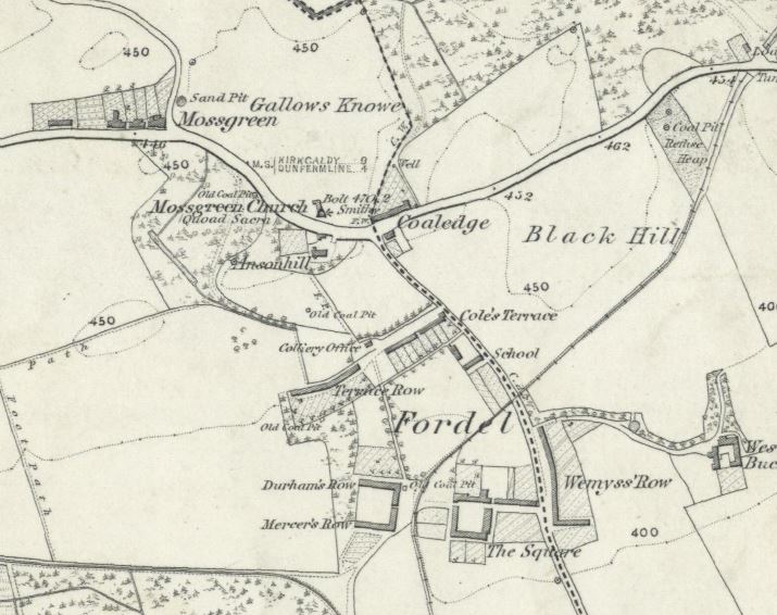
On this map we can see:
The Square, "In the village of Fordel. A square of houses in Fordel Village occupied by Colliers".
Cole's Terrace "A row of neat houses one story in height in Fordel Village, named after the Factor for the Estate. They are all occupied by Colliers."
Mercer's Row "A row of one story houses in Fordel Village occupied by Colliers and named after one of the late proprietors".
Durham's Row, also "named after one of the late proprietors" and lastly Terrace Row , simply "A Row of houses in Fordel Village occupied by Colliers."
There are other collier houses outwith "The Square" at Fordell. There is
Coalton - "¾ mile South of Fordel. Ruins of dwelling houses on the farm of Broomieside and the property of General M. Henderson of Fordel. The name is a contraction from Coal Town, and was occupied formerly by colliers."
Muir Rows - "3/8 mile South of Fordel. Two rows of dwelling houses (one of which is thached [sic] ) on the lands of Fordel, they are occupd [occupied] by colliers and people in indigent circumstances",
Calais Row - "¾ mile SSW [South South West] of Fordel. A small row of dwelling houses on Calais Hill occupied by colliers."
Fordelmuir About 1/2 mile SW [South West] of Fordel. A small row of houses in middling repair occupied by Colliers. The adjoining land was the moorish part of Fordel estate hence the name.".
There is also Crossgates Farm, Muniwick - a farmhouse and offices and Doocoot - a small dwelling place. There is also Burnthill Quarry, a sandstone quarry, and the school in the village which is "supported by the proprietor and Colliers" and the church at Mossgreen.
That sums up the village as for as the Ordnance Survey is concerned. It should be added, though, that Bob Holman also mentions the "store", which was effectively a truck store and the "Coaledge Tavern",one of the local drinking places. Holman says that the locals called it the "College". He writes :
"I cannot come across any person who can tell me the age of Fordell Store, but from the appearance of the building, of which the Store is a part, I venture to say that it is one of the oldest buildings in the village. Moss Row, now demolished, was probably the oldest. It was built to accommodate the miners who were employed in the pits in that locality. Then would follow the Old Square, a continuation of the Store buildings, also demolished, and in front, Cannon Row, which could boast of the only double storey building in Fordell, with the exception of the Store. The erection of these houses, or “ miners’ raws,” brought about the existence of the Store.
The only other buildings at that time would be the School and Schoolhouse, the Auld Raw, in rear of the present Coles Terrace, and two houses at the south end of Wemyss Square. With the exception of the School and the Schoolhouse the other houses are demolished. Since that time, Coles Terrace (1850), Monteith Terrace and Douglas Cottages were erected, and, in recent years, a few of the most modern of houses have been erected on and built near the site of the Lang Raw.
There is no doubt that the Store buildings were erected by the proprietors of the Fordell Coal Company and if the Store was in existence in the early part of the nineteenth century it was one of the many such Stores owned by proprietors of collieries and other works all over the country where goods were exchanged for lines supplied to the workmen instead of wages and must therefore be one of few such buildings. "
"Behind the diamond panes: The story of a Fife mining community", by Bob Holman (1952) p47
I am not sure how to reconcile these differing views on the watering holes of the village. The Ordnance Survey suggest no drinking place, Bob Holman suggests at least a couple but Eric Smipson goes further saying :
"Unlike many of his fellow ministers, the Rev Alexander Watt of Dalgety was ready to praise the colliers who lived in his parish. Writing in the New Statistical Account of 1836, he described the colliers of his parish to be "with a few exceptions, the most sober and civilized of that class of the community anywhere to be found." This was despite the fact that there were, according to an 1842 report, no fewer than fifteen licensed dealers in spirits in Dalgety parish and Crossgates."
Dalgety Bay: Heritage and Hidden History- The Story of the Parish of Dalgety and of the New Town of Dalgety Bay" by Eric Simpson. p. 47
We can see, then, that Fordell was a small but growing mining community. If our WIlliam was, indeed, born "in the colliery" in the parish of Dalgety, it may have been the Fordel colliery that is meant and, if so, then he likely lived in one of these rows.As for now, Eric Simpson comments :
"In recent years some modern bungalows have been built in the area in Coles Place. But what survives of the old Fordell? Opposite the kirkyard, there is Ansonhill House, once the home of the colliery manager. It was built for Admiral Durham who commanded HMS Anson during the French Revolutionary Wars. There is also the old schoolhouse and the nearby Coaledge Tavern, which retains an old style horseshoe-shaped bar. Otherwise, there are only the tombstones in Mossgreen kirkyard, some old day level shafts and a small brick building which once housed some of the outside loos. Only these and a few other fragments remain as tangible reminders of a vanished village."
Dalgety Bay: Heritage and Hidden History- The Story of the Parish of Dalgety and of the New Town of Dalgety Bay" by Eric Simpson. p. 53
Crossgates
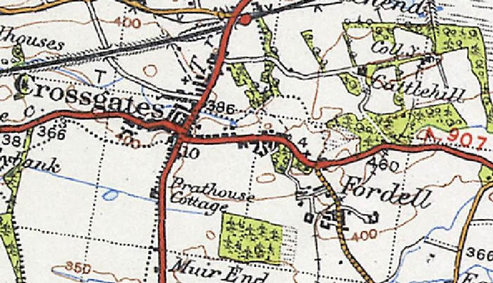
If William was not born in Fordel, the next most likely place would be Crossgates, a place that certainly features in his later life. When William married Margaret Burt in 1833 he is said to be residing at Crossgates they continue to live there at least until the birth of his daughter, Isabella in 1846. At their marriage, Margaret was "residing at Townhill". The distance between Fordel colliery and Crossgates is about three-quarters of a mile and from Crossgates to Townhill is around three and a half miles. It is quite possible to move from one place to another in Crossgates and in doing so move parish from Dalgety to Dunfermline as we see with the birth of William and Margaret's children.
A map from the "A Vision of Britain through Time" web site shows the relationship between Fordell colliery and Crossgates :
The village in more detail from the survey of 1853 :
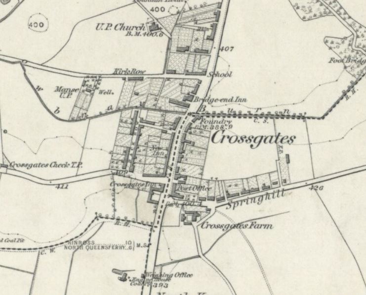
[source]
The authors of the entry for Dunfermline in the "Old Statistical Account" writing in the 1790's estimate that throughout the parish there were some 1,020 men, women and children employed in the coal trade and 200 horses. On the villages in the parish they comment :
“There are 8 villages in the parish the populous villages of Lime kilns and Charlestown and pleasantly situated on the coast of the frith of Forth. Crossford, Halbeath, and Crossgates, are situated on the great turnpike road, which passes through the town and parish of Dunfermline, from the western to the eastern extremity”
The Ordnance Survey of Crossgates between 1853-1855 described it thus :
"1/8 miles East of Halbeath. A tolerably large Village partly in the parish of Dunfermline and partly in Dalgety. It consists of three pretty fair streets and a few scattered houses, the whole are inhabited by mechanics, Colliers, agricultural labourers, and a few respectable families. There are three Inns in the Village a few grocers shops one Cloth Shop and a Post Office. There is no public school-house but the Rev Mr Bruce has hired a private house for one and the Master received for his Salary the pupils fees, the ordinary branches of an English education are taught only."
[source]
Frances Groome's writing in the early 1880's in his "Ordnance Gazetteer of Scotland" described Crossgates this way :
"Crossgates, a village on the mutual border of Dunfermline and Dalgety parishes, Fife, with a station on the North British railway, 3½ miles ENE of Dunfermline. Inhabited chiefly by colliers, it is surrounded at near distances by extensive coal mines; adjoins lines of mineral railway, communicating with St David's harbour on Inverkeithing Bay; and has a post office, with money order, savings' bank, and telegraph departments, 2 hotels, a U.P. church (1802; 531 sittings), and a public school, which, with accommodation for 160 children, had (1880) an average attendance of 124, and a grant of £91, 2s. Pop. (1841) 646, (1861) 1115, (1871) 1181, (1881) 1215. "
And Eric Simpson adds :
Crossgates, which in 1791 was but an insignificant settlement, grew rapidly in the last decade of the eighteenth century and the first decades of the nineteenth. The Crossgates, as it used to be termed, was an excellent situation for the village, sited as it was where two main roads met, one the main road from Dunfermline to Kirkcaldy and the other the main turnpike from Ediburgh to Perth...The village, too, was handily situated for the various collieries and colliery settlements in the surrounding area. Its growth can be measured by the burgeoning number of tradesmen in the village. While in 1791 there was only one craftsman - a blacksmith - in the settlement, by 1814 there was a baker, a cooper, two tailors, four shoemakers, and no fewer than ten carpenters and eleven weavers. Between 1841 and 1891, this village, which was inhabited mainly by colliers, had well nigh doubled its population, reaching by the latter year the figure of 1,165.
Dalgety Bay: Heritage and Hidden History- The Story of the Parish of Dalgety and of the New Town of Dalgety Bay" by Eric Simpson. p. 83
Townhill
Townhill, where William's wife, Margaret, hailed from is described in Groome's 19th Century "Ordnance Gazetteer of Scotland" (which can be found online) as previously being known as Dunfermline Coaltown. It was a colliery village in the parish of Dunfermline and was also known as Moncur in mediaeval times. Its name was changed to Dunfermline Coaltown in the 18th Century and then to Townhill in the early 19th century. Groome writes :
"reflecting its location at the top of a hill leading up from Dunfermline. In 1781-3 a wooden rail track was built to transport coal to Inverkeithing on the Firth of Forth. The village was once the site of the Dunfermline town gallows and the Cairncubie Spring northeast of the village was an important source of drinking water for the town. The last remaining pit at Muircockhall was used for training until it closed in 1970."
A look at the OS map shows Townhill to be much larger than Crossgates itself.
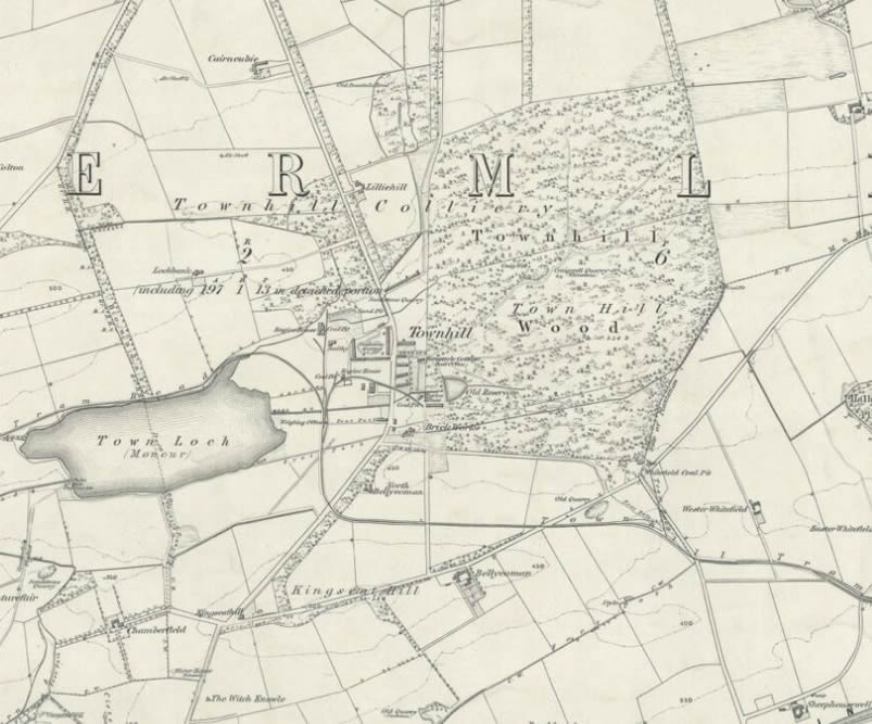
[source]
The Ordnance Survey entry for the village is :
"An irregular built village on the property of the Burgh of Dunfermline, occupied chiefly by the workers of Townhill Colliery." [OS1/13/128/49]
Of Townhill Colliery, itself, it says :
"This Colliery comprises the whole of the mineral of the Burgh lands extending from Townhill to Loch Fitty and from Cairncubie to Muircockhall. At present there are only three Pits opened and they are at Townhill, where the name chiefly applies now." [OS1/13/128/51]
Gardener's Land
The Ramsay family was at Crossgates at least until November 1846 but we know that by 1849, at the time of the birth of their daughter, Christina Burt Ramsay they were living at "Gardener's Land". I searched for more information on this and came across a posting on the Rootsweb SCT-FIFE list which draws heavily on Sheila Pitcairn's book "A History of the Old 'Fitpaths' and Streets of Dunfermline" saying :
There was, and still is - my cousin is a member - a society called "The Ancient Society of Gardeners in and about Dunfermline". Nowadays it operates as a friendly society. In 1815 the Society decided to open its lands, which lay about half-mile to the north-east of the cross of Dunfermline, to feu (that is for building sites). Apparently they were called Happy Land Houses. The first one to be built was Albany House..... Rose Street had many weavers' homes and Albany street, one below it, some of the factories. The next-to-last address of my gg-aunt, Isabella Morris, was given in 1881 as Gardenersland, Dunfermline.
[source]
When I searched the National Library of Scotland maps, I came across a Gardener's Land to the north east of Dunfermline not too far from Townhill and on the main railway line. It is also close to Appin Crescent where William's wife, Margaret's, family were living at the taking of the 1841 Census and South Inglis Street, where they were living at the 1851 Census. It was at this address in South Inglis street that Margaret's mother died in 1864 - although I believe Margaret was, herself, dead by 1861
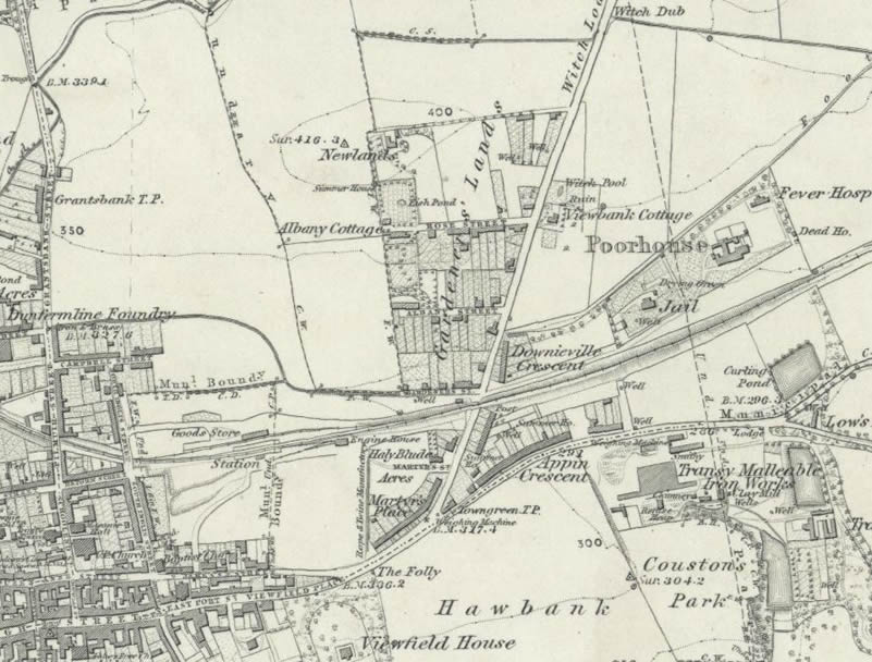
[source]
and the SCRAN Learning Images web site has the following image entitled "Gardener's Land, Dunfermline"
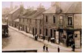
I have not been able to find out any more about this place.
Coal Hill, Kirkcaldy
At the taking of the 1851 Census William's family are said to be residing at "Coal Hill parish of Kirkaldy". This location caused some problems for me originally because I could not see why the William Ramsay's family would move all the way to Kirkcaldy. However, after some online discussion it was suggested that this might be Coal Wynd in Kirkcaldy. I looked for a map of the area and could not find one for the exact period, but a later OS 25 inch map showed the following:
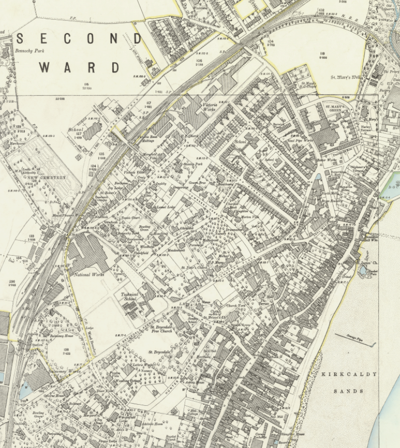
[source]
Scrolling through the pages of the 1851 Census from our own Ramsay family, it can be seen that there are nearby streets named High Street, Kirk Wynd, Railway Station, Back Of Kirkaldy, Townsend Place, Mitchell Street, Coal Hill, Coal Wynd and Hill Place and some of these are clearly visible on the map so I think there can be no doubt that this is the correct location. It is possible that the Hill Place visible on this map could earlier have been Coal Hill.
Auchterderran and Grainger Square
At the taking of the 1861 Census William Ramsay and family are said to be living at Grainger Square, Auchterderran and he is described as an engine driver at a coal pit. Auchterderran was both a parish and a village.
Seven years after the census in 1871, William died aged 67 at "17 Grainger Street, Lochgelly, Auchterderran". He was described as a "Joiner at Colliery (Journeyman)" I think it is reasonable to conclude that this is very near to Grainger Square
Frances Groome's Gazeteer of Scotland entry says :
"Auchterderran, a hamlet and a parish of SW Fife. The hamlet stands ¾ mile N by W of Cadenden Station and 2¾ NE of Lochgelly, a town with a head post office and another station, lying within the western border of this parish. The latter is bounded N by Kinross-shire and Kinglassie, E by Kinglassie and Dysart, SE by Kirkcaldy and Abbotshall, S by Auchtertool SW by Beath, and W by Ballingray. With a very irregular outline, rudely resembling a cross, it has a length from E to W of from 2½ miles, a width of 6 and one-eighth miles, a width N to S from 3 furlongs to 4 and three-eighths miles and an area of 7968½ acres of which 150¼ are water. Loch Gelly (5¾ x 3½ furlongs) lies on the Auchtertool border, and sends off a rivulet to the Ore, a sluggish stream which winds through the middle of the parish from W to E along a low alluvial plain, traversed also by the Dunfermline branch of the North British railway... the Ore very readily overflows its banks.... there are large and well cultivated farms ... Woods occupy some 520 acres ; and the entire surface is parcelled out into arable and pasture lands, plantations, limestone quarries, coal and ironstone mines, thoroughfares etc. The mining interest is very extensive ; and seven collieries, belonging chiefly to the Carboniferous Limestone series, were at work here in 1879 that of Lochgelly being noteworthy for the great fire of 1870-71... Auchterderran forms one quoad sacra parish, and Lochgelly another, both in the Presbytery of Kirkcaldy ... Pop. of quoad sacra portion (1871) 1623, (1881) 1747 ; of entire parish (1881) 4332, of who 2484 were in Lochgelly burgh...” [written between 1882-1885]
The Ordnance Survey entry for the village between 1853 and 1855 reads :
"About 2¼ Miles N.E. [North East] of Lochgelly village. A small Village consisting of the Manse Established Church, School and a farmhouse and offices known by the name of Kirkshots. A Public house and Smithy." [OS1/13/10/39]
On the Scottish Mining Website, David Rorie, is quoted as follows :
"When I went to Auchterderran in 1894 the great bulk of the mining population was composed of the old Fifeshire mining families, who were an industrious, intelligent, and markedly independent class. They worked in various small privately-owned mines, the proprietors of which in most cases had themselves sprung from the mining class, many of them being relatives of their employees; and a certain family feeling and friendship nearly always existed. With the advent of large Limited Liability Companies there was a corresponding extension of the workings, and a huge influx of a lower class of workman from the Lothians and the West country (involving an Irish element), while the small private concerns went inevitably to the wall."
It appears that whilst Grainger Square was in the parish of Auchterderran, it was actually a part of Lochgelly village. As the the Ordnance Survey of 1853-55 says :
"⅝ Mile N. [North] of Lochgelly village. A double row of houses erected by and called after the late Mr Grainger Civil Engineer. They are inhabited by the furnace-men and miners of the Lochgelly Company." [OS1/13/10/36]"
source
The Ordnance Survey map of 1843-45 shows Grainger Square just by the Lochgelly Iron Works :
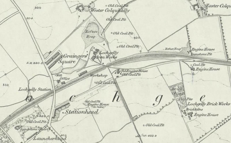
The Scottish Mining Website has a section on "Lochgelly - Its Rise and Progress" and it mentions that the Lochgelly Iron Company built 32 single and 13 double houses.
"For the use of these the workmen are charged - for a single house, 1s 3d fortnightly, and for a double house, 2s 6d fortnightly. They also pay (married men) 7d fortnightly, and (unmarried men) 4d fortnightly, for school fees and medical attendance, the M.D. engaged by the Company being Dr Nelson."
Source
Little Dean, Auchterderran
Little Dean, Auchterderran was where William Ramsay was found living with the Shand family at the taking of the 1871 census where he is described as a "coal miner". I am not sure what "Little Dean" was but I have come across references to Little Dean Road in Auchterderran. Interestingly, the header page for this census return has the description of the area surveyed by the enumerator and it says :
"The southern part of the village of Lochgelly bounded on the north by John Addison Mr Watson Mr Landale David Anderson George Thornton Hugh Paton Alexander Brown Snr and David Adamsons properties which are included in this division. The Farm of Newton and houses at Little Dean Westertown Lochgelly Place and Park Keeper House in this division"
It would seem then that, like Grainger Square, Little Dean is actually in Lochgelly